
Grand Canyon National Park, located in northwestern Arizona, is the 15th site in the United States to have been named as a national park. The park's central feature is the Grand Canyon, a gorge of the Colorado River, which is often considered one of the Wonders of the World. The park, which covers 1,217,262 acres of unincorporated area in Coconino and Mohave counties, received more than 4.7 million recreational visitors in 2022, which is the second highest count of all American national parks after Great Smoky Mountains National Park. The Grand Canyon was designated a World Heritage Site by UNESCO in 1979. The park celebrated its 100th anniversary on February 26, 2019.

The Grand Canyon is a steep-sided canyon carved by the Colorado River in Arizona, United States. The Grand Canyon is 277 miles (446 km) long, up to 18 miles (29 km) wide and attains a depth of over a mile.

Grand Canyon Village is a census-designated place (CDP) located on the South Rim of the Grand Canyon, in Coconino County, Arizona, United States. Its population was 2,004 at the 2010 Census. Located in Grand Canyon National Park, it is wholly focused on accommodating tourists visiting the canyon. Its origins trace back to the railroad completed from Williams, to the canyon's South Rim by the Santa Fe Railroad in 1901. Many of the structures in use today date from that period. The village contains numerous landmark buildings, and its historic core is a National Historic Landmark District, designated for its outstanding implementation of town design.

Starved Rock State Park is a state park in the U.S. state of Illinois, characterized by the many canyons within its 2,630 acres (1,064 ha). Located just southeast of the village of Utica, in Deer Park Township, LaSalle County, Illinois, along the south bank of the Illinois River, the park hosts over two million visitors annually, the most for any Illinois state park.

Navajo Bridge is the name of twin steel spandrel arch bridges that cross the Colorado River in the Grand Canyon National Park in northern Coconino County, Arizona, United States. The newer of the two spans carries vehicular traffic on U.S. Route 89A (US 89A) over Marble Canyon between Bitter Springs and Jacob Lake, allowing travel into a remote Arizona Strip region north of the Colorado River including the North Rim of Grand Canyon National Park.

The Bright Angel Trail is a hiking trail located in Grand Canyon National Park in the U.S. state of Arizona.

The known human history of the Grand Canyon area stretches back 10,500 years, when the first evidence of human presence in the area is found. Native Americans have inhabited the Grand Canyon and the area now covered by Grand Canyon National Park for at least the last 4,000 of those years. Ancestral Pueblo peoples, first as the Basketmaker culture and later as the more familiar Pueblo people, developed from the Desert Culture as they became less nomadic and more dependent on agriculture. A similar culture, the Cochimi also lived in the canyon area. Drought in the late 13th century likely caused both groups to move on. Other people followed, including the Paiute, Cerbat, and the Navajo, only to be later forced onto reservations by the United States Government.

Hermits Rest is a structure built in 1914 at the western end of Hermit Road at the south rim of the Grand Canyon in Arizona, United States. The Hermit Trail, a hiking trail that extends to the Colorado River, begins about ¼ mile beyond the shuttle bus stop at Hermits Rest. Hermits Rest also represents the western terminus of the Rim Trail. The location was named for Louis Boucher. Around 1891, Boucher – a Canadian-born prospector – staked claims below present-day Hermits Rest. With help, Boucher carved the aforementioned trail into the canyon, and for years lived alone at nearby Dripping Springs. The main structure currently standing at Hermits Rest was designed by architect Mary Colter. Hermits Rest is the westernmost point on the canyon's south rim that is accessible by paved road. It was built as a rest area for tourists on coaches operated by the Fred Harvey Company on the way to the now-vanished Hermit Camp. The building was designed to appear to be a natural stone formation, closely tied to the land. Colter selected furnishings that are included in the National Historic Landmark designation.

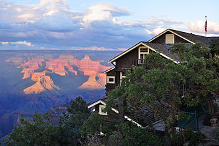
Lookout Studio, known also as The Lookout, is a stone building located on the South Rim of the Grand Canyon, within Grand Canyon National Park in Arizona. It is part of the Grand Canyon Village Historic District, and is part of the Mary Jane Colter Buildings National Historic Landmark. It currently operates as a gift shop and observation station for visitors, with telescopes on its outdoor terrace. Lookout Studio was constructed by the Santa Fe Railway in 1914 and was established as a photography studio to compete with Kolb Studio. It is one of six buildings at the Grand Canyon that were designed by architect Mary Colter, along with Bright Angel Lodge, Hermit's Rest, Hopi House, Phantom Ranch, and Desert View Watchtower. Lookout Studio employs her signature rustic style of using jagged native rocks to imitate indigenous structures of the region and to blend in with the environment.

Desert View Watchtower, also known as the Indian Watchtower at Desert View, is a 70-foot (21 m)-high stone building located on the South Rim of the Grand Canyon within Grand Canyon National Park in Arizona, United States. The tower is located at Desert View, more than 20 miles (32 km) to the east of the main developed area at Grand Canyon Village, toward the east entrance to the park. The four-story structure, completed in 1932, was designed by American architect Mary Colter, an employee of the Fred Harvey Company who also created and designed many other buildings in the Grand Canyon vicinity including Hermit's Rest and the Lookout Studio. The interior contains murals by Fred Kabotie.

Grand Canyon Village Historic District comprises the historic center of Grand Canyon Village, on the South Rim of the Grand Canyon in Grand Canyon National Park, Arizona. The district includes numerous landmark park structures, many of which are National Historic Landmarks themselves, or are listed on the National Register of Historic Places. The town design as a whole is also significant for its attention to integration with the Grand Canyon landscape, its incorporation of National Park Service Rustic design elements, and for the idiosyncratic design of park concessioner structures such as the El Tovar Hotel.
The Kolb Studio is a historic structure situated on the edge of the South Rim of the Grand Canyon in Grand Canyon Village within Grand Canyon National Park in Arizona. It was operated from 1904 until 1976 as the photographic studio of brothers Ellsworth and Emery Kolb.

Cataract Canyon is a 46-mile-long (74 km) canyon of the Colorado River located within Canyonlands National Park and Glen Canyon National Recreation Area in southern Utah. It begins at Colorado's confluence with the Green River, and its downstream terminus is the confluence with the Dirty Devil River. The lower half of the canyon is submerged beneath Lake Powell when the lake is at its normal high water elevation of 3,700 feet (1,100 m).

The historical buildings and structures of Zion National Park represent a variety of buildings, interpretive structures, signs and infrastructure associated with the National Park Service's operations in Zion National Park, Utah. Structures vary in size and scale from the Zion Lodge to road culverts and curbs, nearly all of which were designed using native materials and regional construction techniques in an adapted version of the National Park Service Rustic style. A number of the larger structures were designed by Gilbert Stanley Underwood, while many of the smaller structures were designed or coordinated with the National Park Service Branch of Plans and Designs. The bulk of the historic structures date to the 1920s and 1930s. Most of the structures of the 1930s were built using Civilian Conservation Corps labor.

Grand Canyon Conservancy, formerly known as Grand Canyon Association, is the National Park Service's official non-profit partner of Grand Canyon National Park, raising private funds, operating retail shops within the park, and providing premier guided educational programs about the natural and cultural history of the region. Supporters fund projects including trails and historic building preservation, educational programs for the public, and the protection of wildlife and their natural habitat.

The historical buildings and structures of Grand Teton National Park include a variety of buildings and built remains that pre-date the establishment of Grand Teton National Park, together with facilities built by the National Park Service to serve park visitors. Many of these places and structures have been placed on the National Register of Historic Places. The pre-Park Service structures include homestead cabins from the earliest settlement of Jackson Hole, working ranches that once covered the valley floor, and dude ranches or guest ranches that catered to the tourist trade that grew up in the 1920s and 1930s, before the park was expanded to encompass nearly all of Jackson Hole. Many of these were incorporated into the park to serve as Park Service personnel housing, or were razed to restore the landscape to a natural appearance. Others continued to function as inholdings under a life estate in which their former owners could continue to use and occupy the property until their death. Other buildings, built in the mountains after the initial establishment of the park in 1929, or in the valley after the park was expanded in 1950, were built by the Park Service to serve park visitors, frequently employing the National Park Service Rustic style of design.
Inscription "B" is a survey mark that was left at the confluence of the Colorado and Green rivers in Utah in 1889 by the Robert Brewster Stanton party as they surveyed a railway route.
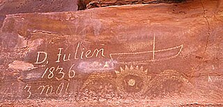
The Denis Julien Inscription is an incised carving on a rock face in a side canyon of the Green River north of Canyonlands National Park in southwestern Grand County, Utah, United States. The site is about 750 feet (230 m) to the east of the Green River in Hell Roaring Canyon, at the top of a talus slope. The inscription was left by trapper Denis Julien in 1836, when he was one of the few Europeans in southern Utah. The panel reads:
D. Julien
1836
3 mai
The Denis Julien Inscription was left on a rock face in 1838 along the Green River in Moffat County, Colorado by Denis Julien, a French-American trapper who was one of the few Europeans in the area in the 1830s. Julien made a practice of leaving his mark on locations along the Green and Colorado rivers, leaving at least eight such marks. Four, including the Colorado mark, are listed on the National Register of Historic Places.
Architects of the National Park Service are the architects and landscape architects who were employed by the National Park Service (NPS) starting in 1918 to design buildings, structures, roads, trails and other features in the United States National Parks. Many of their works are listed on the National Register of Historic Places, and a number have also been designated as National Historic Landmarks.

